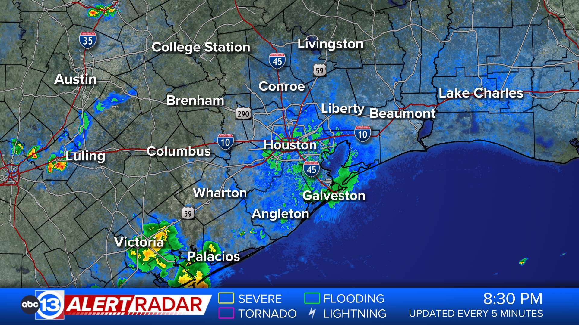
ABC13 Houston Weather Radar for Southeast Texas

- Coastal Flood Advisory
* WHAT...Minor coastal flooding expected. * WHERE...Gulf-facing beaches, including the Matagorda Peninsula, Brazoria County beaches, Galveston Island and the Bolivar Peninsula. * WHEN...Through Sunday evening. * IMPACTS...Flooding of lots, parks, and roads with only isolated road closures expected. * ADDITIONAL DETAILS...Water levels are expected to approach 4 feet above mean lower low water. This could result in standing water on Highway 87 near Highway 124 on the Bolivar Peninsula as well as near the Lynchburg Ferry and for low lying portions of Toddville Road in Seabrook.More
- Coastal Flood Advisory
* WHAT...Dangerous surf and rip currents are likely at the beaches. Minor coastal flooding expected. * WHERE...Gulf-facing beaches, including the Matagorda Peninsula, Brazoria County beaches, Galveston Island and the Bolivar Peninsula. * WHEN...Through Sunday evening. * IMPACTS...Hazardous swimming conditions conditions. Flooding of lots, parks, and roads with only isolated road closures expected.More
- Beach Hazards Statement
* WHAT...High rip current risk in effect through this evening and potential for minor coastal flooding for the Saturday and Sunday morning high tide cycles. * WHERE...Gulf-facing beaches, as well as low-lying locations on the western shores of Galveston Bay. * WHEN...Through Sunday evening. * IMPACTS...Hazardous swimming conditions conditions.More
- Rip Current Statement
* WHAT...For the Coastal Flood Advisory, minor coastal flooding. For the High Rip Current Risk, dangerous rip currents. * WHERE...Aransas Islands, Kleberg Islands, Nueces Islands and Calhoun Islands Counties. * WHEN...For the Coastal Flood Advisory, until 7 PM CDT this evening. For the High Rip Current Risk, through this evening. * IMPACTS...Flooding of lots, parks, and roads with only isolated road closures expected. Rip currents can sweep even the most experienced swimmers away from shore into deeper water. These rip currents can become life-threatening to anyone entering the surf.More
- Coastal Flood Advisory
* WHAT...For the Coastal Flood Advisory, minor coastal flooding. For the High Rip Current Risk, dangerous rip currents. * WHERE...Aransas Islands, Kleberg Islands, Nueces Islands and Calhoun Islands Counties. * WHEN...For the Coastal Flood Advisory, until 7 PM CDT this evening. For the High Rip Current Risk, through this evening. * IMPACTS...Flooding of lots, parks, and roads with only isolated road closures expected. Rip currents can sweep even the most experienced swimmers away from shore into deeper water. These rip currents can become life-threatening to anyone entering the surf.More
- Flood Warning
...The Flood Warning continues for the following rivers in Texas... Trinity River near Moss Bluff affecting Chambers and Liberty Counties. For the Trinity River...including Crockett, Riverside, Romayor, Goodrich, Liberty, Moss Bluff...Minor flooding is forecast. * WHAT...Minor flooding is occurring and minor flooding is forecast. * WHERE...Trinity River near Moss Bluff. * WHEN...Until early Monday morning. * IMPACTS...At 12.2 feet, Minor lowland flooding begins in the vicinity of the gage. * ADDITIONAL DETAILS... - At 7:30 PM CDT Saturday the stage was 12.4 feet. - Bankfull stage is 9.2 feet. - Recent Activity...The maximum river stage in the 24 hours ending at 7:30 PM CDT Saturday was 12.6 feet. - Forecast...The river is expected to fall below flood stage early tomorrow afternoon. - Flood stage is 12.2 feet. - Flood History...This crest compares to a previous crest of 12.4 feet on 10/20/2006. - http://www.weather.gov/safety/floodMore
- Wind Advisory
* WHAT...Southeast winds 25 to 30 mph with gusts up to 40 mph. * WHERE...Bolivar Peninsula, Brazoria Islands, and Galveston Island Counties. * WHEN...Until 7 AM CDT Sunday. * IMPACTS...Gusty winds will blow around unsecured objects. Tree limbs could be blown down and a few power outages may result.More