ABC13 Houston Weather Radar for Southeast Texas

- Special Weather Statement
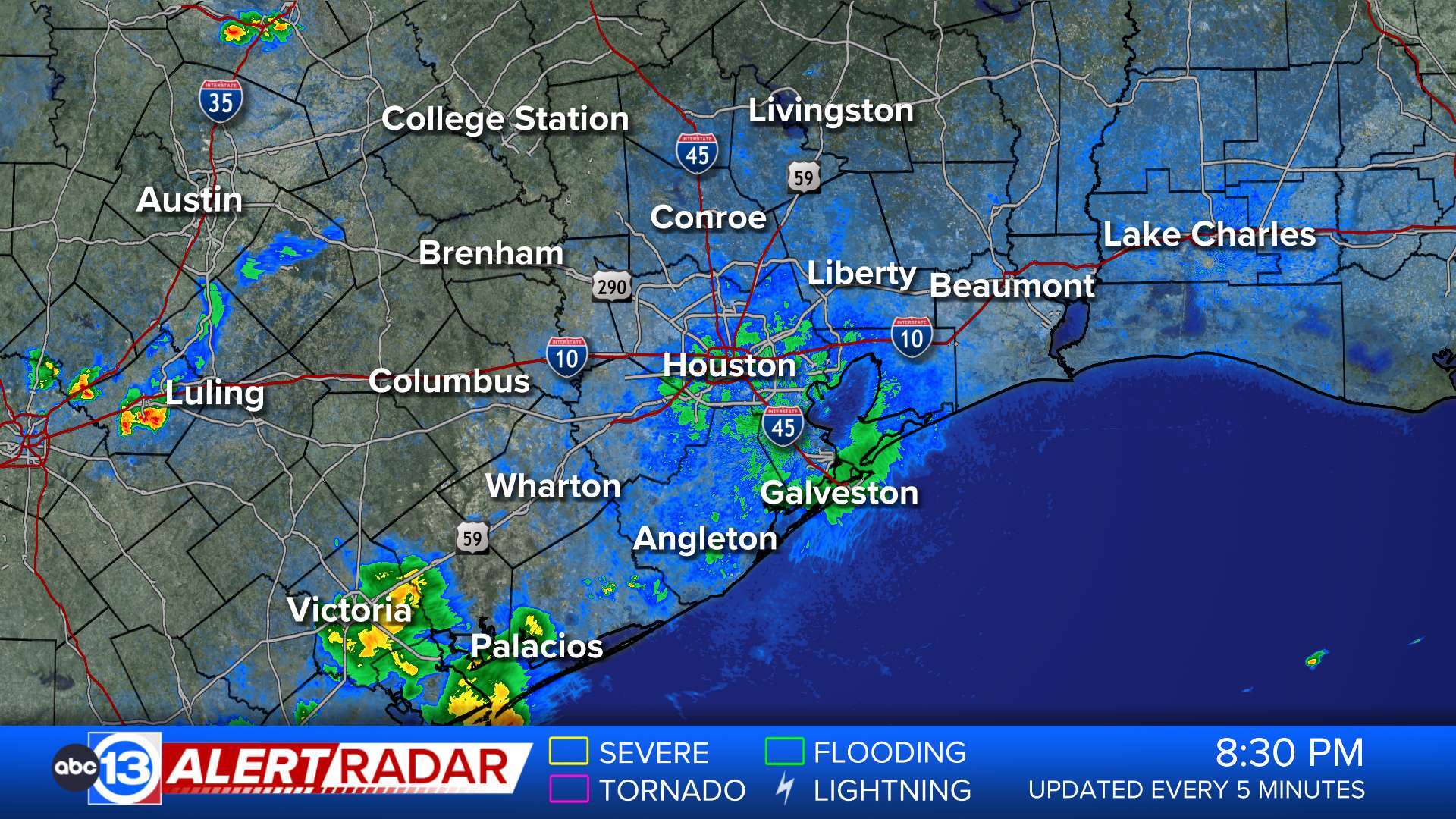
At 611 AM CDT, Doppler radar was tracking strong thunderstorms along a line extending from near Huntsville State Park to Montgomery to Todd Mission. Movement was southeast at 35 mph. HAZARD...Wind gusts up to 50 mph. SOURCE...Radar indicated. IMPACT...Gusty winds could knock down tree limbs and blow around unsecured objects. Locations impacted include... Conroe, Tomball, Willis, Pinehurst, The Woodlands, Oak Ridge North, Panorama Village, Shenandoah, Magnolia, Cut And Shoot, New Waverly, Montgomery, Stagecoach, Woodloch, Todd Mission, The Woodlands Pavillion, Huntsville State Park, Lake Conroe Dam, Dobbin, and Plantersville.More
- Severe Thunderstorm Warning
SVRHGX The National Weather Service in League City has issued a * Severe Thunderstorm Warning for... East central Montgomery County in southeastern Texas... Southern San Jacinto County in southeastern Texas... Northwestern Liberty County in southeastern Texas... * Until 630 AM CDT. * At 605 AM CDT, a severe thunderstorm was located near North Cleveland, or near Cleveland, moving east at 30 mph. HAZARD...60 mph wind gusts and quarter size hail. SOURCE...Radar indicated. IMPACT...Hail damage to vehicles is expected. Expect wind damage to roofs, siding, and trees. * Locations impacted include... Cleveland, Shepherd, Coldspring, North Cleveland, Tarkington Prairie, and Evergreen.More
- Flood Advisory
* WHAT...Flooding caused by excessive rainfall is expected. * WHERE...A portion of southeast Texas, including the following counties, Brazos and Grimes. * WHEN...Until 815 AM CDT. * IMPACTS...Minor flooding in low-lying and poor drainage areas. Water over roadways. * ADDITIONAL DETAILS... - At 603 AM CDT, local law enforcement reported heavy rain in the advisory area due to thunderstorms. Minor flooding is ongoing or expected to begin shortly. Between 1 and 2 inches of rain have fallen. - Reports have been received of water beginning to cover the feeder roads along Highway 6 in Navasota. - Some locations that will experience flooding include... Navasota. - http://www.weather.gov/safety/floodMore
- Flood Warning
...Forecast flooding changed from Minor to Moderate severity for the following rivers in Texas... Trinity River near Moss Bluff affecting Chambers and Liberty Counties. For the Trinity River...including Moss Bluff...Moderate flooding is forecast. * WHAT...Minor flooding is occurring and moderate flooding is forecast. * WHERE...Trinity River near Moss Bluff. * WHEN...Until further notice. * IMPACTS...At 15.2 feet, Moderate lowland flooding begins in the vicinity of the gage. * ADDITIONAL DETAILS... - At 3:30 AM CDT Thursday the stage was 14.3 feet. - Bankfull stage is 9.2 feet. - Recent Activity...The maximum river stage in the 24 hours ending at 3:30 AM CDT Thursday was 14.3 feet. - Forecast...The river is expected to rise to 16.0 feet early Tuesday morning. Additional rises are possible thereafter. - Flood stage is 12.2 feet. - Flood History...This crest compares to a previous crest of 15.2 feet on 06/03/2016. - http://www.weather.gov/safety/floodMore
- Flood Warning
...The Flood Warning continues for the following rivers in Texas... Trinity River at Liberty affecting Liberty County. For the Trinity River...including Liberty...Major flooding is forecast. * WHAT...Major flooding is occurring and major flooding is forecast. * WHERE...Trinity River at Liberty. * WHEN...Until further notice. * IMPACTS...At 27.0 feet, Moderate lowland flooding begins as roads into several outlying communities above Liberty are closed with residents in 5 or 6 subdivisions cut off if not evacuated. * ADDITIONAL DETAILS... - At 3:15 AM CDT Thursday the stage was 29.7 feet. - Bankfull stage is 21.0 feet. - Recent Activity...The maximum river stage in the 24 hours ending at 3:15 AM CDT Thursday was 29.7 feet. - Forecast...The river is expected to rise to a crest of 31.2 feet early Sunday morning. - Flood stage is 26.0 feet. - Flood History...This crest compares to a previous crest of 31.0 feet on 10/21/1994. - http://www.weather.gov/safety/floodMore
- Flood Warning
...The Flood Warning is extended for the following rivers in Texas... Trinity River near Goodrich affecting Polk, Liberty and San Jacinto Counties. For the Trinity River...including Goodrich...Moderate flooding is forecast. * WHAT...Moderate flooding is occurring and moderate flooding is forecast. * WHERE...Trinity River near Goodrich. * WHEN...Until further notice. * IMPACTS...At 38.0 feet, Moderate lowland flooding begins. * ADDITIONAL DETAILS... - At 3:45 AM CDT Thursday the stage was 39.4 feet. - Bankfull stage is 36.0 feet. - Recent Activity...The maximum river stage in the 24 hours ending at 3:45 AM CDT Thursday was 41.4 feet. - Forecast...The river is expected to rise to a crest of 40.7 feet just after midnight tonight. - Flood stage is 36.0 feet. - Flood History...This crest compares to a previous crest of 40.5 feet on 03/30/2018. - http://www.weather.gov/safety/floodMore
- Flood Watch
* WHAT...Flooding caused by excessive rainfall continues to be possible. * WHERE...A portion of southeast Texas, including the following areas, Austin, Brazos, Burleson, Coastal Harris, Colorado, Grimes, Houston, Inland Harris, Madison, Montgomery, Northern Liberty, Polk, San Jacinto, Southern Liberty, Trinity, Walker, Waller and Washington. * WHEN...Through Friday afternoon. * IMPACTS...Excessive runoff may result in flooding of rivers, creeks, streams, and other low-lying and flood-prone locations. * ADDITIONAL DETAILS... - Another round of heavy rainfall and thunderstorms is expected to develop over Southeast Texas tonight once again. Grounds are very saturated, so any additional rainfall will be slow to drain. This can more easily lead to street flooding and additional rises on area rivers, creeks and streams. Additional rainfall totals of 2 to 4 inches can be expected. Isolated higher amounts will be possible. - http://www.weather.gov/safety/floodMore
- Flood Warning
...The Flood Warning continues for the following rivers in Texas... East Fork San Jacinto near New Caney affecting Harris, Montgomery and Liberty Counties. For the East Fork San Jacinto River...including Cleveland, New Caney...Moderate flooding is forecast. * WHAT...Moderate flooding is occurring and moderate flooding is forecast. * WHERE...East Fork San Jacinto near New Caney. * WHEN...Until early Tuesday morning. * IMPACTS...At 68.5 feet, Moderate lowland flooding continues with water over the lowest slab elevations of buildings on the downstream side near the gauge, as well as several hunting camps along the left bank approximately 2 miles downstream of the gauge begin to take on water. Widespread flooding continues in the vicinity of the gauge and in the right floodplain with many roads including FM 1485 inundated and closed. * ADDITIONAL DETAILS... - At 8:16 PM CDT Wednesday the stage was 67.6 feet. - Bankfull stage is 54.5 feet. - Recent Activity...The maximum river stage in the 24 hours ending at 8:16 PM CDT Wednesday was 70.1 feet. - Forecast...The river will fall below flood stage Friday evening to 57.7 feet early Saturday morning. It will then rise above flood stage early Saturday morning to 62.6 feet early Sunday morning. It will fall below flood stage again early Monday afternoon. - Flood stage is 58.0 feet. - Flood History...This crest compares to a previous crest of 67.7 feet on 05/19/1989. - http://www.weather.gov/safety/floodMore
- Rip Current Statement
* WHAT...Dangerous rip currents. * WHERE...Aransas Islands, Kleberg Islands, Nueces Islands and Calhoun Islands Counties. * WHEN...Through Thursday morning. * IMPACTS...Rip currents can sweep even the most experienced swimmers away from shore into deeper water. These rip currents can become life-threatening to anyone entering the surf.More